
The Atlas of Memory Maps exhibit features maps drafted by non-experts in an effort to preserve the memory of their hometowns, which had been destroyed or radically transformed during and after World War II. Most were published in Yizkor books, memorial books compiled by Jewish survivors. The exhibition is mostly in Polish, but includes some English-language information. The maps contain notations in Yiddish or Hebrew. This virtual exhibition by Grodzka Gate-NN Theatre Center includes maps from Poland, Belarus, Ukraine, Lithuania, Moldavia and Slovakia.
I found a map of Skierniewice among over 150 included in the exhibition. My grandfather Hil Majer Piwko was born in there in 1854, as were his siblings Jankel Wolf (1857), Urysz (c. 1861), Dawid (1862, d. 1865), Nusen Dawid (1866), Chawa (c. 1871), and Fajga (c. 1878). It’s where Hil Majer brought his bride Hinda Walfisz in 1873, and where they started their own family. It’s also where his parents were buried (Cywia Rajch in 1862 and Chaim Josef in 1912), and probably his stepmothers, too.
Here is the map from the exhibition:
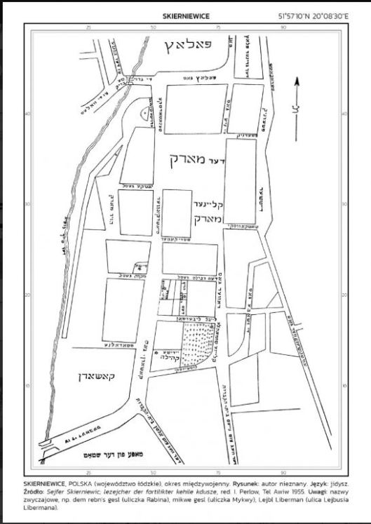
Map of prewar Skierniewice drawn from memory by an unknown author
Comparing it with a contemporary map, it’s hard to figure out exactly how they match up. Maybe someone who can read Yiddish can help me by translating the words on the map. Please leave me a comment if you do! I think the rivers on each map are the same, and the space marked with crosses in the bottom center of the prewar map may be the green space marked “Church of St. Stanislaus” in the bottom right of the contemporary map.

Map of contemporary Skierniewice. The site of the synagogue is marked with a black dot surrounded by a grey circle. Source: Google Maps
I’ve been to Skierniewice twice, with my cousin Krysia in 2013 and with my cousin Bob in 2018. Little remains of the town’s Jewish heritage.


With cousin Bob, the former synagogue in the background–it’s now an electrical supply store
The synagogue, though the exterior is well maintained, now houses an electrical supply store. On the road running parallel to the river, a few tombstones have survived in the old Jewish cemetery, but they are in what is currently the backyard of a private residence. I wonder if this cemetery was included on the prewar map? The newer Jewish cemetery contains many more surviving tombstones as well as commemorative markers outlining the history of the town’s Jewish population. It is located beyond the bottom edges of these maps, off a dirt road a short ride south of town.
Located in Lublin, Grodzka Gate-NN Theatre is one of the oldest and most active Jewish heritage organizations in Poland. About its origins, Tomasz Pietrasiewicz writes:
The changes brought about by the fall of communism in Poland in 1989 initiated the process of regaining Memory by the Polish society, and Lublin was among many Polish cities which had to face their forgotten past.
When we began our activities at the Grodzka Gate [which historically separated the Jewish and Catholic districts of the city] in the early 1990s, we knew nothing about the history of Jews in Lublin. We were not aware that the enormous empty space on one side of the Gate conceals the Memory of the Jewish Quarter. We did not realize that the Gate leads to the non-existent town, the Jewish Atlantis.There is a huge parking area, lawns and new roads where there used to be houses, synagogues and streets. A large part of this area, including the foundations of the former Jewish houses, was buried under a concrete cover, and the memory of those who lived here was hidden as well. You cannot understand Lublin’s history without these empty spaces near the Gate. For the NN Theatre, they have become a natural setting for artistic actions, Mysteries of Memory, which uncover the memory of the past while mourning the victims of the Holocaust. (from “History of Grodzka Gate-NN Theatre“).
More information about the exhibition and Grodzka Gate-NN Theatre can be found at the following websites:
Grodzka Gate-NN Theatre Center

I can see the Yiddish word for synagogue, it that helps.
LikeLike
Yes! Is it anywhere near where I marked on the contemporary map? About a block down from the large open space that was probably the market square (called Rynek in Polish).
LikeLike
The map is from the Skierniewice Memorial Book by Sefer Skernievitz.
https://digitalcollections.nypl.org/search/index?utf8=%E2%9C%93&keywords=skierniewice
LikeLiked by 1 person
Thank you for sharing this information! I will add this source information to the main post.
LikeLike
Some Jewish immigrants took the ship to America at the port of Antwerpen, Belgium.
On FamilySearch you will find the “Antwerp Police Immigration Index, 1840-1930”.
When selecting on birthplace Skierniwice you will find persons.
With this information look for document with “Stad Antwerpen” of a person.
On the document on (3) is the address of the father, On (4) the addres of the mother and on (6) the last address of the person outsite Belgium.
It gives an impression where the persons lived in Skierniewice.
LikeLike
I will check this out. Thank you!
LikeLike
Marysia, If it helps, the word at the top is Palace. Under that, Palace Street. Under that, vertical, the New Street, under that, The Market, under that, the Small Market, under that the Rabbi’s Alley (small street), then Laybl Liberman, and below that one of them on the left is the German Congregation. Vertically on the left, the road to the old (??? hard to read) and on the right, the road to the new (???? hard to read). Some of the rest are just names of people or places that I don’t recognize. Pshednik. Senatadske. I could probably make out some other places if I could print the map, but it is hard to twist
LikeLike
I really appreciate this Roberta. I am working on a translated map and I’ll use your comments as I piece it all together!
LikeLike
If you look in a previous comment, there’s a link to the Yizkor Book which has a higher resolution image of the map that is easier to read
LikeLike
Actually, with the clearer map I can make out quite a bit. Originally I thought it was an obscure name, but Senatarske might mean Senator with the added suffix ske. Some other things are The Green Place (der greyner plats), Butcher’s Alley (yatke gesl), Pig Market (Khazer Mark), New Street (nayer gas), The Big Bridge (der groiser brik), To the Glassworks (tsu der Hute), To the “Vales” (tsu der vales), Train (Ban), and lots more. Kasern is probably Barracks or Armory on the lower left. I don’t have time to do more right now, but if you could mail me a clear map, I would fill in the translations for you in the right places.
LikeLike
Thanks Roberta. So much great information. I’m going to sit down today and see if I can put it all together.
LikeLike
I think associating the large group of crosses with a church may be throwing you off. It might even be a Jewish cemetery, since that seems to be at the heart of a lot of Jewish activity. Although the crosses aren’t labeled, the parcel exactly next to the crosses is labeled Jewish Community (Yiddish Kehile). That entire plot is surrounded by the streets: Kashern Gas (maybe Kosher Street), Laybl Liberman, Small (undeciphered), Lutshinski. The block directly above that has, in the center, three vertical rectangles, labeled the Rabbi’s Courtyard. In close proximity are Bet HaMikdash and Mikva Alley. I am translating Gesl as Alley. Could be Lane or some other word for a small street. Hope this helps. I also just figured out how to rotate the map. Much easier on the eyes.
LikeLike
More for me to work on! Thank you!
LikeLike
If you like to puzzle, some old maps of Skierniewice (russian: Скерневице).
http://igrek.amzp.pl/result.php?cmd=pt&locsys=1&uni=-749584&box=0.0001&hideempty=on
LikeLike
Wow. Another great resource. I also found historical maps of Włocławek, too!
LikeLike
Perhaps (old) street names of Skierniewice are to be found at USHMM:
https://collections.ushmm.org/search/catalog.html?f%5Bf_cities%5D%5B%5D=Skierniewice
https://collections.ushmm.org/search/?per_page=120&q=Skierniewice+(Poland)&search_field=subject
LikeLike
A somewhat strange source. Found a map of the ghetto of Skierniewice with street names. It would be interesting to know if the ghetto is plotted on a (memory) map of around 1940-1943 or on a recent map.
https://commons.wikimedia.org/wiki/File:Mapa_Getta_w_Skierniewicach.jpg
In October 1940, the Nazis created in Skierniewice a ghetto whose limits were the southern part of the Square and Rawska, Stanisławska, Strykowska, Piotrkowska, Barania, Poprzeczna, Krótka and Floriana Streets.
https://sztetl.org.pl/en/towns/s/523-skierniewice/116-sites-of-martyrdom/50683-ghetto-skierniewice
LikeLike
More leads to follow. Thank you!
LikeLike
Pingback: Skierniewice Map Translations and More | Uncovering Jewish Heritage
And more maps of Skierniewice.
Map of Skierniewice (no date mentioned).
With German names on the map (no date mentioned).

Maps of the ghetto of Skierniewice (1941) in Polish and German.
https://kehilalinks.jewishgen.org/Skierniewice/Shoa%20.html
LikeLike
These are interesting. The comment on the first map says it’s from sometime before 1990. Looking at all of these, it’s still not clear which building lot corresponds with the still standing building that used to be a synagogue. The intersection is drawn differently on each of the maps. Maybe the road was rerouted sometime after the war?
It’s also notable that the two ghetto maps have different borders; the second covers a much smaller area.
LikeLike
My maternal grandparents came from Skiernewice and Rawa. They emigrated to the UK and were tailors in the West End of London. I don’t have any map information about the town, but I do have quite a few family photos. The family name was Lemel (grandfather) and Fershigete (grandmother). I live in New York. My name is Ruth Antrich.
LikeLike
I wonder if our ancestors know each other? My Piwko relatives lived in Skierniewice and my Ranch relatives lived in Rawa Mazowiecka. You’re so fortunate to have photographs. I would love to see them
LikeLike